
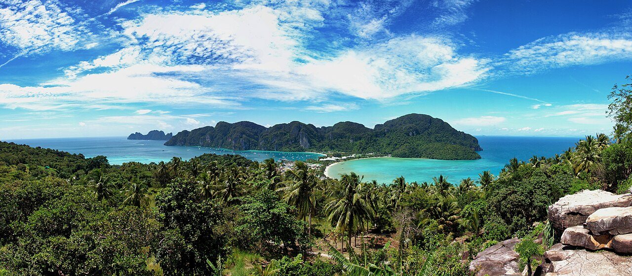
Phi Phi island map basics start with two islands. Phi Phi Don is the large, inhabited one that holds every hotel, bar and ferry pier, and Phi Phi Leh is the small, uninhabited one with Maya Bay, reachable only by boat. Phi Phi Don is made of two hilly halves joined by a narrow, flat isthmus, and the village, the main pier and two bays, Tonsai and Loh Dalum, sit on that strip, one bay on each side.
This Phi Phi island map guide shows where everything is, which pier is which, how far each beach is on foot or by longtail, and what the Thai names on a map mean. It draws on Wikipedia, Phuket 101, Hotels.com neighbourhood guides, Phuket Ferry, Thailand Ferry Booking, Isla Guru and a schematic map from Wikimedia Commons. Sources disagree on a few distances and on the park fee, and we say where.
- Phi Phi Don
- 10.27 km², about 8 km long
- From Phuket
- 40 to 46 km, sources differ
- Main pier
- Tonsai Pier, ฿20 fee
- Cars on the island
- None, only walkways
- Ton Sai to Long Beach
- 5 min by longtail
- Ton Sai to Laem Tong
- 40 to 45 min by longtail
What does a Phi Phi island map show?
A Phi Phi island map shows Phi Phi Don as two hilly halves joined by a narrow isthmus. Ferries dock at Tonsai Pier on the south side of the isthmus, Loh Dalum Bay is a short walk north, Long Beach is south-east, and Laem Tong and Loh Bagao are on the quiet north and east coasts, reached by longtail. Phi Phi Leh, with Maya Bay, lies south of the main island and has no hotels.
Phi Phi Island Map at a Glance: Two Islands and a Narrow Isthmus
The group lies in the Andaman Sea, 46 km south-east of Phuket according to Wikipedia, while Phuket 101 rounds the distance to 40 km. Wikipedia lists six islands with a combined area of 12.06 km². Phi Phi Don covers 10.27 km², Phi Phi Leh 1.28 km², Ko Mai Phai (Bamboo Island) 0.27 km² and Ko Yung (Mosquito Island) 0.21 km², and the two Bida islets are smaller still. Only Phi Phi Don has residents and hotels, about 2,500 people in 2018, says Wikipedia.
Phi Phi Don is about 8 km long and 3.5 km wide, and the flat strip between its two halves holds the largest settlement and most resorts. The Phi Phi island map below labels the north-east half Ko Nai and the south-west half Ko Nok, and the isthmus sits where the ferry symbol is. The map is schematic, so use the 200 m scale bar for rough distances only, because the paths climb and twist.
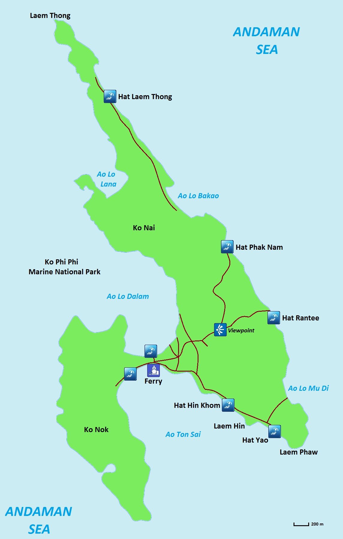
- Ferry (Tonsai Pier)On the isthmus, on the south shore of Ao Ton Sai, with the village around it.
- Ao Lo Dalam (Loh Dalum Bay)The north side of the isthmus, a short walk from the pier.
- Hat Hin Khom, Laem Hin, Hat YaoThe south-east shore: a small beach, a rocky cape, then Long Beach.
- ViewpointOn the hill above the village, where the main paths meet.
- Hat Rantee, Hat Phak Nam, Ao Lo BakaoThe quiet east coast, reached by boat or long trails.
- Hat Laem ThongThe long beach near the northern tip, mostly resorts.
Interactive Phi Phi island map
To zoom in on a single street or bay, use the interactive Phi Phi island map below, drawn by OpenStreetMap contributors. Scroll or pinch to zoom, or open the larger map in a new tab. Place names there depend on what local mappers entered, so cross-check them with the table in the next section.
View larger map | Map data © OpenStreetMap contributors
How to Read a Phi Phi Island Map: Thai Names and Spellings
Every Phi Phi island map spells the Thai names its own way, which is why one beach can appear as Hat Yao, Haad Yao or Long Beach. A few Thai words unlock most labels: Ko means island, Ao means bay, Hat means beach and Laem means cape or headland. The table matches the names on the Commons map to the spellings you will meet on booking sites and signs.
| On the map | Also written | What it is |
|---|---|---|
| Ao Ton Sai | Tonsai Bay | The south-side bay with the ferry pier and the village |
| Ao Lo Dalam | Loh Dalum, Lo Dalam Bay | The north-side bay with a shallow beach and beach bars |
| Hat Yao | Long Beach, Haad Yao | The long beach on the south-east coast, a short boat ride from the pier |
| Hat Hin Khom, Laem Hin | Hin Khom | A small beach and a rocky cape between the village and Long Beach |
| Ao Lo Mu Di | Loh Moo Dee | A quiet bay next to Long Beach, joined by a short trail |
| Hat Rantee | Rantee Bay, Ranti | A mostly undeveloped east-coast beach reached by boat or a hard jungle hike |
| Hat Phak Nam | Pak Nam, Paknam | An east-coast beach on the unmarked trail beyond viewpoint 3 |
| Ao Lo Bakao | Loh Bagao, Loh Ba Kao | The north-east bay, about 800 m wide, with bungalows and a small village |
| Hat Laem Thong | Laem Tong, Laem Thong | The long sandy beach at the northern end, mostly resorts |
| Ko Nai, Ko Nok | None | The map's names for the north-east and south-west halves of Phi Phi Don |
If a hotel address or booking page spells a beach differently from your Phi Phi island map, match it by the description in the right-hand column and not by the spelling.
Phi Phi Island Map: Piers, Ferries and Where You Arrive
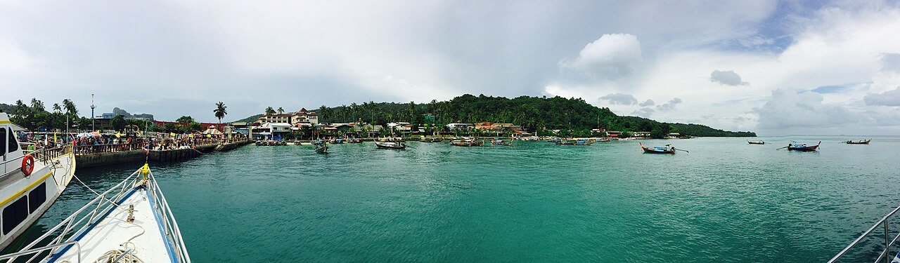
On any Phi Phi island map the ferry symbol sits at Tonsai Pier, and almost everyone arrives there. Phuket Ferry calls it the island's main pier, in the heart of Tonsai Bay, served by boats from Phuket's Rassada Pier, Krabi's Klong Jilad Pier, Koh Lanta's Saladan Pier and the Railay East floating pier. Thailand Ferry Booking adds that it is the busiest pier and lists a long run of routes, including Ao Nang, Koh Lipe, Koh Samui and Krabi airport.
| Landing | Where it is | Who uses it | What to know |
|---|---|---|---|
| Tonsai Pier | Centre of Tonsai Bay, on the isthmus | Ferries and speedboats from Phuket, Krabi, Koh Lanta and Railay | ฿20 fee in cash. Check in with your operator's sign and arrive 30 minutes before departure |
| Longtail stand at Tonsai Pier | Same pier | Short hops and charters | Phuket Ferry says longtails leave from here for nearby places such as Maya Bay |
| Resort piers at Laem Tong | Northern end of the island | Resort shuttle boats and some speedboats | Thailand Ferry Booking says shuttles usually drop guests at the resort's own pier |
| Floating pier at Loh Samah Bay | Phi Phi Leh | Tour boats for Maya Bay | A boardwalk of about five minutes leads to the beach, says Phuket 101 |
Wikipedia says tourists pay a 20-baht fee at Ton Sai Pier. The Thaiger reported in April 2010 that the Ao Nang local administration collects it to pay for cleaning the island's piers, and that Phuket tour operators objected because they were given no notice. Phuket Ferry calls it an entry fee that helps maintain the pier's facilities, so keep ฿20 in cash for the Phi Phi island map's busiest corner.
One operator's page, P.P. Sabai Marine on Phuket Ferry, tells passengers to arrive at least 30 minutes before a departure and to look for the company's sign at Tonsai Pier. Arrivals are met by people holding banners for tours and hotels, says Thailand Ferry Booking, and Phuket Ferry notes Wi-Fi spots and fire shows at sunset around the pier. Our Phi Phi ferry guide compares operators, and the guides to Phuket to Phi Phi and Krabi to Phi Phi cover the routes in detail.
Laem Tong and resort piers
Laem Tong is the northern end of Phi Phi Don on every Phi Phi island map, and it is the one area where you may not use Tonsai Pier at all. Thailand Ferry Booking says resort shuttle boats usually drop guests at the resort's private pier, and Hotels.com says a longtail between Laem Thong and Loh Dalum takes about 40 minutes. Our guide to Laem Tong Beach covers the resorts and boat options. If you book a resort there, ask which pier your boat uses before you leave the mainland.
Phi Phi Island Map by Area: Where Each Bay and Beach Sits
The table turns the Phi Phi island map into a quick comparison of areas. Travel times from the pier follow in the section on getting around. Sources sometimes disagree, so read the times as ranges.
| Area | Where | Character |
|---|---|---|
| Tonsai Village and Bay | Centre of the isthmus, south shore | The hub: pier, shops, restaurants, ATMs, tour desks |
| Loh Dalum Bay | North side of the isthmus | Shallow water, beach bars and fire shows |
| Ton Sai Beach (far end) | West end of Tonsai Bay | Isolated, soft sand, bungalows, kayaks and cliff climbing |
| Long Beach (Hat Yao) | South-east coast | Soft sand, clear water and easy snorkeling |
| Monkey Beach | Western shore | A small cove with macaques; a stop on most boat tours |
| Loh Bagao | North-east coast | Quiet long beach, stylish hotels and a small village |
| Laem Tong | Northern tip | Upscale resorts, a fishing village and calm water |
| Rantee Bay | East coast | Undeveloped, with no facilities |
Ton Sai and Loh Dalum: the centre of the Phi Phi island map
Hotels.com describes the central area as running from Tonsai Bay, where the pier is, north to Loh Dalum, with four sub-areas: Tonsai West, Tonsai Village, Loh Dalum and Tonsai East. Tonsai West is the quietest and the other three are lively. The Tonsai Bay guide says most places in the village are within about a 10-minute walk and that the bay is nearly 2 km long between its outer points, with tall cliffs on the west side and shallower water and hotels on the east. Phuket 101 puts Loh Dalum Bay at about 160 m wide. Our guide to where to stay in Phi Phi compares the areas for sleeping.
Long Beach and the south-east
Long Beach lies at the eastern end of Tonsai Bay, cut off from the village by a rocky cape that a narrow jungle path crosses, says Hotels.com. Shark Point, a rock just offshore, faces Phi Phi Leh at the mouth of the bay. Longtails run to Long Beach by day and night, and the walk takes 20 to 30 minutes on a rocky path that you should not use in the dark. Beyond it, Loh Moo Dee is a quieter bay with little more than sand and sea. Read our Long Beach Phi Phi guide for resorts and sunsets.
North and east coast: Laem Tong, Loh Bagao and Rantee
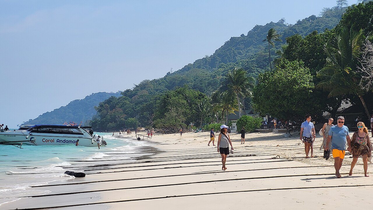
The east coast is about 4 km long and remote, with small bungalow resorts, and Hotels.com says it is only accessible by boat unless you fancy two hours of trekking on steep jungle trails. Loh Bagao has stylish hotels and a small village with local bars, and Phuket 101 gives its beach as about 800 m wide. At the northern end, Laem Thong is a long strip of sand with resorts, a fishing village and a couple of bars, and Bamboo Island lies about 5 km off its tip. Isla Guru describes Rantee as natural and undeveloped, with no facilities. Our best beaches in Phi Phi guide ranks them.
West coast: Monkey Beach
Monkey Beach is a small cove on the western shore. Isla Guru says you can reach it by longtail from Tonsai Village or by kayak from Loh Dalum Bay, and that macaques come onto the sand, so keep your belongings secure and do not feed them. Touropia warns that at very high tide little beach is left. See our Monkey Beach Phi Phi guide for rules and timing.
Phi Phi Island Map Beyond Phi Phi Don: Leh, Bamboo and Mosquito Island
The rest of the Phi Phi island map is open water and a handful of uninhabited islands, all reached by boat. Phi Phi Leh lies south of Phi Phi Don and holds Maya Bay, Pileh Lagoon and Viking Cave. Wikipedia says Maya Bay was closed to visitors from June 2018 until January 2022 and that the 2000 film The Beach was partly shot on Phi Phi Leh. Boats no longer enter the bay. Phuket 101 says they moor at a floating pier in Loh Samah Bay, visitors are capped at 375 an hour, swimming is not allowed and boats only slow down at Viking Cave so passengers can look from the water.
Maya Bay closes every August and September, and Time Out reported on 29 September 2026 that it reopened on 1 October 2026. Our Maya Bay guide has the current rules, and our guide to Phi Phi Leh covers the island itself.
Bamboo Island, or Ko Mai Phai, is uninhabited and has no facilities, according to Isla Guru. Distances vary by source: Phuket 101 and Krabi Nature say about 5 km north of Phi Phi Don, while Phuket 101's islands page says 8 km north-east. Mosquito Island, or Ko Yung, lies about 2 km from Bamboo Island and access has been restricted at times, as our Bamboo Island Phi Phi guide explains. Boat trips that link these stops are covered in our Phi Phi island hopping and Phi Phi island tour guides.
Most of the Phi Phi Islands lie inside Hat Noppharat Thara-Mu Ko Phi Phi National Park, though Wikipedia says parts of Phi Phi Don fall outside the park's jurisdiction and are run by the Ao Nang local administration. For the park fee, Thai National Parks lists ฿200 for foreign adults and ฿100 for children, while a Bangkok Post report from early 2024 describes a separate island fee of ฿400 and ฿200 on top, and Phuket 101 quotes ฿400 for the Maya Bay area. We could not confirm which applies at the booth, and group tours usually include it. Our Phi Phi Don guide covers the main island in more depth.
Getting Around a Phi Phi Island Map Without Cars
There are no cars on Phi Phi, says Phuket 101. Locals move goods by cart, the walkways are narrow, and Hotels.com adds that bicycles are used locally. In practice you walk, hop on a longtail, or charter a boat, and the Phi Phi island map explains why: the beaches outside the isthmus are separated by headlands and jungle, so water is the shortcut.
| From Tonsai Pier to | On foot | By boat |
|---|---|---|
| Loh Dalum Bay | 1 to 2 minutes | Not needed |
| Ton Sai Beach (far end) | About 10 minutes along the beach | Not needed |
| Viewpoint trailhead | About 5 minutes; 1.4 km and 20 to 25 minutes each way to the top, says Getting Stamped | Not needed |
| Long Beach | 20 to 30 minutes on a rocky path; Hotels.com says about 30 | About 5 minutes by longtail |
| Loh Bagao | Over an hour, says Phuket 101 | 20 to 30 minutes by longtail |
| Laem Tong | No direct walk; a coastal path links it with Loh Bagao | 40 to 45 minutes by longtail |
| Maya Bay | Not possible | Tour boat to the Loh Samah floating pier, then a boardwalk of about 5 minutes |
| Bamboo Island | Not possible | Roughly 30 to 60 minutes, sources differ |
Phuket 101 quotes ฿100 per person by day for the Long Beach longtail, ฿150 in the evening and ฿200 after midnight, and says private longtail day trips usually cost ฿1,500 to ฿3,000, which is worth splitting. For a Bamboo Island run, the same site gives about ฿1,500 to ฿2,500. Agree the fare, the waiting time and whether the park fee is included before you board. Two guides, Hotels.com and Thailand Ferry Booking, say the village goes quiet once the last big ferry leaves at around 2:30 pm, but timetables change with the season, so confirm yours in our ferry guide.
Walk only in daylight. The rocky path to Long Beach is a bad idea after dark, and for the viewpoint Backpackers Wanderlust says to bring a torch if you plan to come down after sunset. Our Phi Phi viewpoint guide has tickets and timings.
Phi Phi Island Map Practical Points: Cash, Clinic, Fees and Safety
Services follow the same geography as the Phi Phi island map: nearly everything is on the isthmus.
- Cash and shops: Phuket 101 says Tonsai Village has ATMs, convenience stores, pharmacies and a medical clinic. We found no source that lists ATMs on the east coast or at Laem Tong, so bring cash before you take a boat there.
- Pier fee: ฿20 in cash at Tonsai Pier, as covered above.
- Viewpoint tickets: recent guides say ฿50 for viewpoints 1 and 2 and ฿20 more for viewpoint 3, while older ones say ฿30, as our viewpoint guide explains.
- Park fee: ฿200 or ฿400 for adults depending on the source, usually included in group tours.
- Emergency numbers: Tourist Police 1155, medical rescue 1669 and police 191, according to Smartraveller.
Know the tsunami signs too. Wikipedia says the 26 December 2004 tsunami reached 3 m in Tonsai Bay and 6.5 m in Loh Dalum Bay and destroyed about 70% of the buildings on the island, and that a memorial stands on the beach facing Loh Dalum Bay. Backpackers Wanderlust says the trail to the viewpoint is signed for the Tsunami Evacuation Route. Look for the arrows on your first walk, and read our Phi Phi tsunami safety guide for the details. For sleeping, compare Phi Phi hotels and Phi Phi hostels by area.
Three Ways to Use a Phi Phi Island Map on Your First Day
These sample routes are our own suggestions, built from the times above. None is an official itinerary.
Two hours: stay on the isthmus
Drop your bag, walk to Loh Dalum Bay, then take the stairs to the viewpoint, about 5 minutes to the start and roughly 30 minutes to the top. Backpackers Wanderlust allows one to two hours for all three viewpoints with breaks. You end back among the restaurants before dark.
An afternoon: Long Beach
Take a longtail from the pier, about 5 minutes, and spend the afternoon swimming or snorkeling, then walk back in daylight or ask a driver to collect you. Check the return fare before you leave the pier. Keep time for dinner in the village; our Phi Phi restaurants guide has ideas.
A full day: the western and southern islands
Charter a longtail or join a group trip that links Monkey Beach, Pileh Lagoon, the Maya Bay pontoon and Bamboo Island. Use our things to do in Phi Phi guide to pick the stops, and our best time to visit Phi Phi guide to avoid the August and September Maya Bay closure.
Phi Phi Island Map FAQ
Where is Tonsai Pier on a Phi Phi island map?
It is in the centre of Tonsai Bay, on the isthmus that joins the two halves of Phi Phi Don. The schematic map marks it with a ferry symbol. Loh Dalum Bay is a short walk to the north.
How big is Phi Phi Don?
Wikipedia gives 10.27 km², about 8 km long and 3.5 km wide. The whole group of six islands covers 12.06 km².
How far is Phi Phi from Phuket?
Wikipedia says 46 km south-east of Phuket and Phuket 101 says 40 km. Ferries and speedboats leave from Rassada Pier in Phuket Town.
Are there cars on Phi Phi?
No. Phuket 101 says there are no cars, only narrow walkways, and locals move goods by cart.
How far is Long Beach from Tonsai Pier?
About 5 minutes by longtail, or 20 to 30 minutes on foot along a rocky path. Hotels.com says about 30 minutes. Do not walk it at night.
How do I get to Laem Tong?
By longtail, which takes 40 to 45 minutes from Tonsai Pier, or by a resort shuttle boat that docks at the resort's own pier. Hotels.com says Loh Bagao and Laem Tong are linked by a coastal path.
Is there an ATM on Phi Phi?
Yes. Phuket 101 and Hotels.com list ATMs in Tonsai Village. We found no source for ATMs elsewhere on the island, so bring cash for the east coast and Laem Tong.
What is the 20-baht fee at Tonsai Pier?
A small entry or clean-up fee collected at the pier. The Thaiger reported in 2010 that the Ao Nang local administration collects it to pay for cleaning the island's piers. Pay in cash.
Which part of the Phi Phi island map is best to stay in?
Tonsai and Loh Dalum suit first-timers who want restaurants and boats nearby, Long Beach suits quiet beach days, and Laem Tong suits resort stays. Our where-to-stay guide compares them.
Where is Maya Bay on a Phi Phi island map?
On Phi Phi Leh, south of Phi Phi Don. Boats moor at a floating pier in Loh Samah Bay, and a short boardwalk leads to the beach. It is closed every August and September.
Ready to cross to the island?
Compare ferries, speedboats and travel times to Tonsai Pier from Phuket, Krabi and Koh Lanta.
Photo credits: Map of Ko Phi Phi Don by Tournasol7 (CC BY-SA 4.0, Wikimedia Commons); Isthmus panorama by AgentMR (CC BY-SA 3.0 de, Wikimedia Commons); Tonsai Pier panorama by Jmex (CC BY-SA 4.0, Wikimedia Commons); Speedboat on the beach by Renek78 (CC0, Wikimedia Commons); Interactive map data © OpenStreetMap contributors (ODbL).
This guide is compiled from published maps, travel guides and ferry information, checked on 30 October 2026. Distances and times are approximate and boat schedules, fees and rules around Koh Phi Phi change often, so confirm them locally before you travel.