
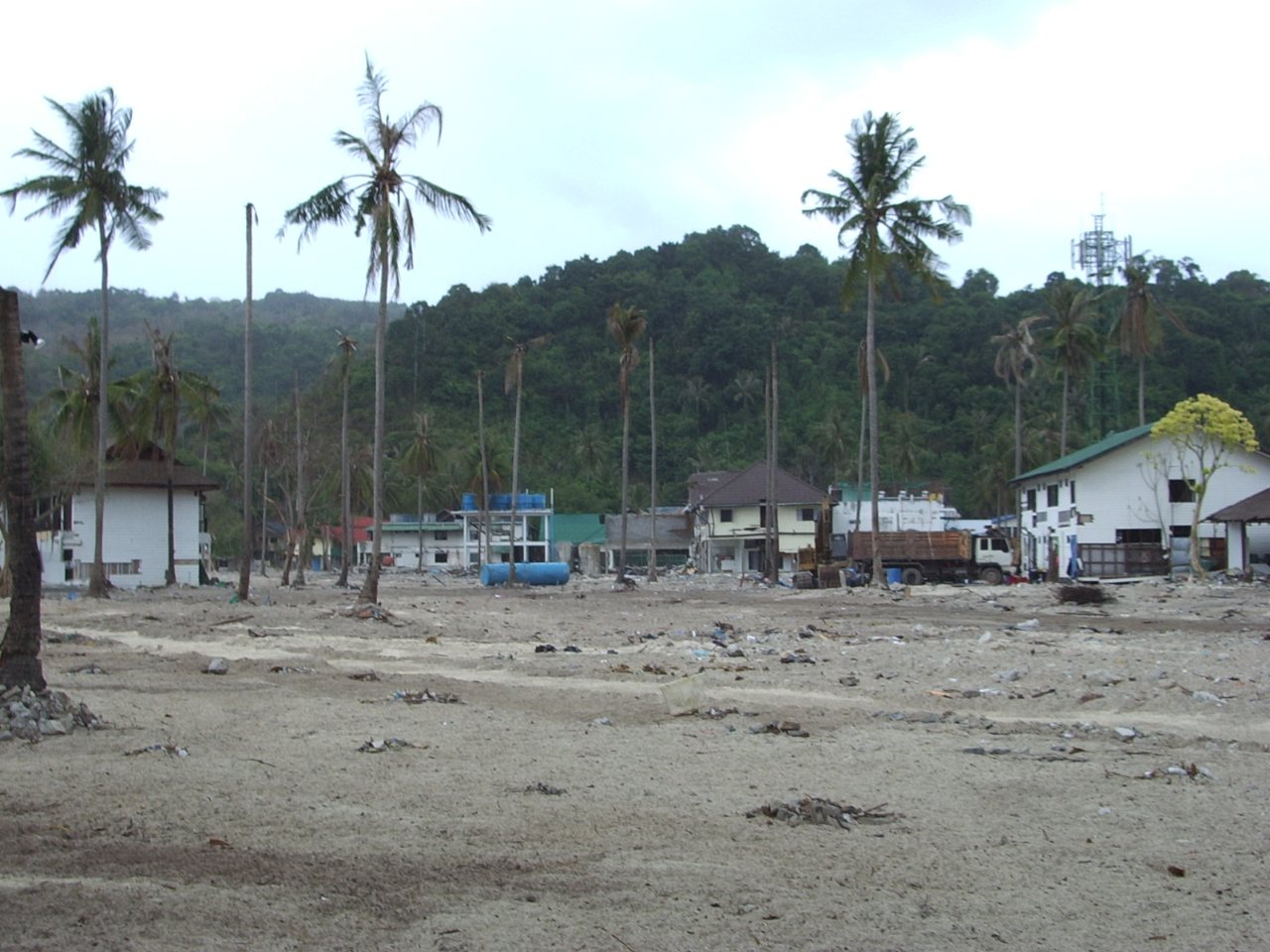
Phi Phi tsunami safety matters more here than on most beaches, because the main village sits on a low strip of land between two bays. The Indian Ocean tsunami of 26 December 2004 struck both sides of that strip, and Wikipedia says about 70% of the island's buildings were destroyed. The island has been rebuilt and a network of warning towers now covers the Andaman coast, so preparation comes down to three things: the natural warning signs, the alert wording and where the high ground is.
This Phi Phi tsunami guide covers what happened, how Thailand's warning system works, what to do and where to go on Phi Phi Don, and the everyday sea risks that are more likely to affect your trip. It draws on Wikipedia, the Bangkok Post, The Nation Thailand, the Thaiger, the US National Weather Service, Smartraveller and Thai Holiday Guide. It is general information and not official advice, and sources disagree on some figures and times, which we flag.
- Phi Phi tsunami date
- 26 December 2004
- Tonsai Bay wave
- About 3 m
- Loh Dalum wave
- About 6.5 m
- Village height
- Under 2 m above sea
- Evacuation point
- Viewpoint hill
- Emergency
- 1669 medical, 1155 police
What should you do in a Phi Phi tsunami?
In a Phi Phi tsunami the rule is simple: if you feel a strong earthquake, see the sea rise or fall suddenly, or hear a tower alert, go to high ground at once and do not wait for confirmation. On Phi Phi Don the official evacuation point is the viewpoint hill above Tonsai, reached by the blue-signed route. Stay up there until officials say it is safe.
Phi Phi Tsunami of 2004: What Happened on the Island
The earthquake struck off Sumatra at 07:58 local time on 26 December 2004, with a magnitude of 9.1 to 9.3 depending on the estimate, according to Wikipedia. The tsunami reached Thailand's Andaman coast about two hours later, and the page says there was no tsunami warning system in the Indian Ocean at the time. In Thailand it counts 5,395 confirmed deaths and 2,817 missing, with at least 2,464 of the confirmed dead foreigners.
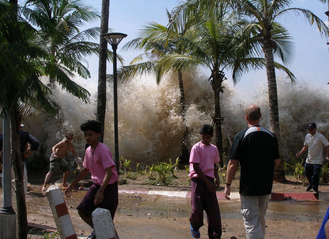
Waves and timing on Phi Phi
Wikipedia says the water drew back shortly after 10:00 and the Phi Phi tsunami arrived at 10:37, with waves of about 3 m in Tonsai Bay and 6.5 m in Loh Dalum Bay. The village stands on a sandy isthmus that rises less than 2 m above sea level, and the waves from both bays met in the middle. Its page on Ko Phi Phi Don gives the time as 10:29 to 10:32 and describes three waves, the second destroying the wooden buildings and the third, the largest, the stone ones. The two pages differ on the minutes, so treat the exact timing with caution.
Deaths and recovery
About 10,000 people, including tourists, were on the island, says Wikipedia's page on the Phi Phi Islands. By the end of July 2005 about 850 bodies had been recovered and about 1,200 people were still listed as missing, and the page says the total number of deaths is unlikely ever to be known. It adds that local guides cite 4,000 and that 104 surviving children had lost one or both parents, while the page on Ko Phi Phi Don says more than 1,000 people died. We treat these as a range, not a count.
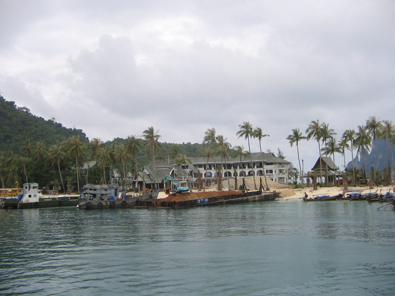
Recovery from the Phi Phi tsunami was quick by the standards of a disaster. Wikipedia says 23,000 tonnes of debris had been removed by the end of July 2005, 300 businesses had reopened and by 6 December 2005 nearly 1,500 hotel rooms were open. It also says that by the same date the Thai government had installed an early-warning alarm system with the help of volunteers.
A memorial honours the dead. The page on Ko Phi Phi Don says it stands on the beach facing Loh Dalum Bay, with a small service each year and a moment of silence at the time the wave struck. The page on the Phi Phi Islands says a memorial was removed in 2015 to make way for a new hotel. We could not reconcile the two, so ask locally if you want to visit.
Phi Phi Tsunami Warning System: Towers, Alerts and Tests
Thailand built its warning network after the 2004 tsunami, and the Phi Phi tsunami warning system is part of it. In a report for the 20th anniversary, the Bangkok Post says about 130 towers were built across the six Andaman provinces, that the Department of Disaster Prevention and Mitigation (DDPM) runs the system and that the National Disaster Warning Centre tests it daily at 8 am. It adds that buoys were installed in the Andaman Sea and that messages are available in Thai, English, German, Japanese and Chinese. The report also says that existing towers need repair and refurbishment.
For Phi Phi itself, the Thaiger reported in October 2018 that the island had four towers and that the ones at Ton Sai Bay and the Ban Koh Phi Phi school were not relaying the signal in a test. Signals are sent by satellite to 32 towers across the Krabi region, and tests had moved to every Wednesday from August 2018. That report is old and we found no source on the current state of the Phi Phi towers, so do not assume that a siren will sound before a Phi Phi tsunami reaches the shore.
The Nation Thailand lists three broadcast messages from the towers, which the table sets out.
| Message | What the tower says | What to do |
|---|---|---|
| M2 | An undersea earthquake has occurred and a tsunami may follow | Evacuate immediately, without waiting for confirmation |
| M3 | A tsunami has now occurred | Most urgent evacuation, move to high ground now |
| M9 | The situation has returned to normal | All clear, but follow official instructions |
Phi Phi Tsunami Warning Signs: What to Do Without an Alert
Smartraveller says that if you are near the coast and advised to evacuate, or you notice signs of a tsunami, you should move to high ground immediately and not wait for official alarms or sirens. The US National Weather Service lists the natural signs: a strong or long earthquake while you are on the coast, the ocean suddenly rising or falling, and a loud roar from the ocean. The Nation adds a wall-like wave crest and unusual animal behaviour.
Wikipedia says the sea drew back on Phi Phi shortly after 10:00 in 2004, so in any Phi Phi tsunami a retreating sea is a signal to leave and not to look. The steps below combine the guidance in those sources.
- Go at once. Do not wait for a siren, a text message or confirmation from anyone.
- Go up, not along the beach. The Nation says to move at least 3 km inland or to ground at least 15 m above sea level, or into a sturdy building of four or more storeys.
- Do not try to outrun the water on flat ground. The Nation says waves in Thailand in 2004 travelled at 36 to 45 km/h, faster than a person can run.
- Stay up. The National Weather Service warns that dangerous flooding and strong currents may last several hours or days after the first wave.
- On a boat, stay in deep water and do not return to shore until the authorities confirm it is safe, says The Nation.
- Go back only when local officials tell you it is safe.
Where to Go on Phi Phi Don in a Phi Phi Tsunami: The Evacuation Hill
The island's official tsunami evacuation point is the viewpoint hill above Tonsai, says Thai Holiday Guide, which notes blue signs on the route up. The same page gives about 320 concrete steps from the village to the ticket counter and says reaching Viewpoint 2, about 180 m above the sea, takes 30 to 45 minutes at a moderate pace. In a Phi Phi tsunami the aim is height and not the viewpoint itself, and The Nation gives ground at least 15 m above sea level as the target.
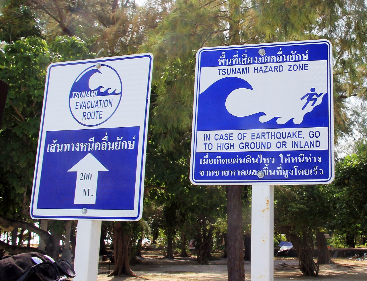
Walk the route once, in daylight, soon after you arrive, so you know where the blue signs start before any Phi Phi tsunami alert. The rock becomes slippery after rain, says the same page, so wear shoes with grip. Our Phi Phi viewpoint guide describes the climb and the other viewpoints.
| Where you are | What to do |
|---|---|
| Tonsai Village or the isthmus | Head uphill along the blue signs toward the viewpoint hill. Wikipedia says the isthmus rises less than 2 m above sea level. |
| A beach or resort elsewhere on the island | Ask your hotel at check-in where the nearest high ground and route are. Our guide to Phi Phi Don describes the areas. |
| On a boat or ferry | Stay in deep water, follow the crew and do not return until the authorities confirm it is safe. |
Phi Phi Tsunami Safety When You Choose Where to Stay
The Thai Hotels Association's southern chapter calls for annual evacuation drills and properly maintained evacuation signs and warns that some hotels may take these for granted, according to the Bangkok Post. For Phi Phi tsunami safety it is reasonable to ask three questions at check-in: where is the nearest high ground, which way do guests go, and when did the hotel last practise.
Our guides to where to stay in Phi Phi and Phi Phi hotels compare the areas, our Phi Phi Don guide describes the island and our Phi Phi island map shows where the village, the bays and the hill sit. You can use the same questions in any of them.
Beyond the Phi Phi Tsunami: Sea Conditions, Boats and Emergency Numbers
Rough seas are a more common hazard. The Thaiger reported on 13 January 2025 that officials temporarily banned swimming and tourist boats at Phi Phi Island and put up red flags after strong winds and rough seas in the northeast monsoon, with forecast waves of 1 to 2 m in the Andaman Sea and 2 to 3 m offshore. Smartraveller warns that ferry and speedboat travel can be dangerous and that serious incidents involving tourists have caused deaths, and it says snorkelling rules require a life vest.
Check the weather before any crossing or boat trip. Our guide to the best time to visit Phi Phi explains the seasons, our ferry guide covers the crossings and our snorkeling guide covers the water stops.
| Service | Number |
|---|---|
| Tourist Police | 1155 |
| Medical emergencies and rescue | 1669 |
| Police | 191 |
| Fire and rescue | 199 |
Smartraveller also advises comprehensive travel insurance that covers medical costs including evacuation, and says to check that the policy covers the activities you plan to do.
Phi Phi Tsunami FAQ
Is Koh Phi Phi safe from a tsunami?
No coast can be called risk-free, and a Phi Phi tsunami is rare but not impossible. Thailand's Andaman coast was hit in 2004 and a network of towers now covers it, but the Bangkok Post says towers need repair and we found no current report on the four on Phi Phi. Learn the natural signs and the route to the evacuation hill.
When did the Phi Phi tsunami happen?
The Phi Phi tsunami struck on 26 December 2004. One Wikipedia page gives the arrival as 10:37 and another gives 10:29 to 10:32, so the exact minutes are uncertain.
How high was the Phi Phi tsunami?
Wikipedia gives about 3 m in Tonsai Bay and 6.5 m in Loh Dalum Bay. The village sits on an isthmus less than 2 m above sea level.
How many people died in the Phi Phi tsunami?
The total is unlikely ever to be known. Wikipedia says about 850 bodies had been recovered and about 1,200 people were missing by the end of July 2005, and its page on Ko Phi Phi Don says more than 1,000 died. Local guides cite 4,000.
Where is the tsunami evacuation point on Phi Phi Don?
Thai Holiday Guide says the viewpoint hill above Tonsai is the island's official evacuation point, with blue signs on the route up.
What are the warning signs of a Phi Phi tsunami?
A strong or long earthquake on the coast, the ocean suddenly rising or falling, and a loud roar from the ocean, says the US National Weather Service. The Nation also lists a wall-like wave and unusual animal behaviour.
What should I do in a Phi Phi tsunami alert?
Move to high ground at once. The Nation says the M2 message means a tsunami may follow and that you should evacuate immediately without waiting for confirmation.
Is there a Phi Phi tsunami warning system?
The Thaiger reported four towers on the island in October 2018, two of which were not relaying the signal in a test, and Wikipedia says an alarm system was installed by December 2005. We found no current status, so do not rely on a siren alone.
Who do I call in an emergency on Phi Phi?
Smartraveller lists 1155 for the Tourist Police, 1669 for medical emergencies and rescue, 191 for the police and 199 for fire and rescue.
Planning around the weather?
Our best-time guide explains the seasons, the rain and the sea conditions around the island, so you can choose your dates.
Photo credits: Phi Phi Don in March 2005 by GainLine (CC BY-SA 3.0, Wikimedia Commons); The 2004 wave at Ao Nang by David Rydevik (Public domain, Wikimedia Commons); Harbour of Koh Phi Phi, December 2005 by Dirk Weber (author assumed by Commons) (Public domain, Wikimedia Commons); Tsunami signs on Ko Poda by Karelj (Public domain, Wikimedia Commons).
This guide is compiled from published reports, Wikipedia and official safety pages, checked on 30 October 2026. It is general information and not official advice, so follow the instructions of local authorities and your accommodation.